Safety Action Plan
On April 22, 2025, the City of Batesville adopted their Safety Action Plan developed under the USDOT SS4A Program. This plan was developed based on the requirements established by the USDOT for SS4A Safety Action Plans. The Batesville Safety Action Plan consisted of the following eight action plan components:
- Leadership Commitment and Goal Setting
- Planning Structure
- Safety Analysis
- Engagement and Collaboration
- Equity Considerations
- Policy and Process Change
- Strategy and Project Selections
- Progress and Transparency
Each of these components can be found within the final adopted plan which can be accessed below.
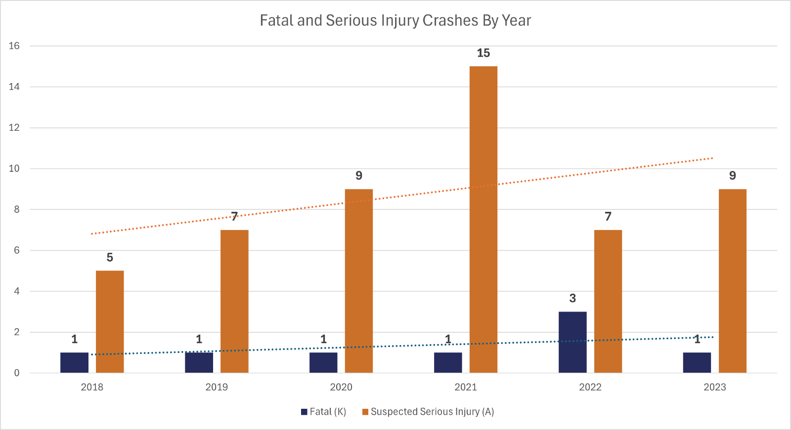
Goal Setting: As a part of the plan development, the City of Batesville established a goal of attaining a 50% reduction in fatal and serious injury crashes by 2035 and a long-term goal of eliminating fatal and serious crashes on the network by 2045. Below is a chart showing the past 5 years of fatal and serious injury crash data in the City of Batesville.
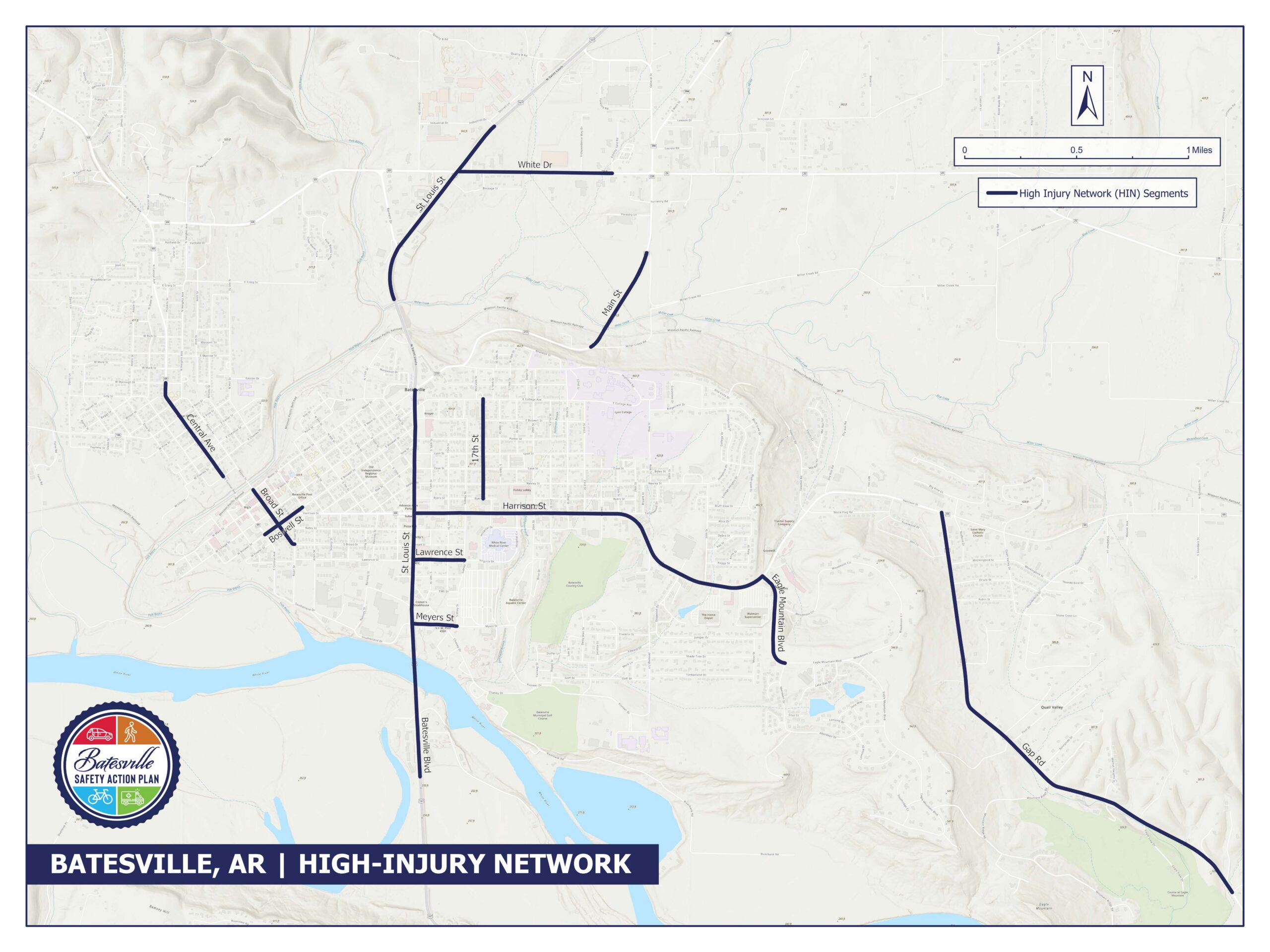
Safety Analysis: A component of a Safety Action Plan is developing a High Injury Network (HIN). The HIN contains the roadway segments and intersections which have the highest concentration of fatal and serious injury crashes. For the Batesville Safety Action Plan, the HIN network consisted of the segments and intersections with high frequencies of these fatal and serious injury crashes as well as locations where Vulnerable Road User (VRU) crashes occurred. VRUs are identified as non-motorized road users such as pedestrians and bicyclists.
Prioritization: A prioritization process was performed to determine the locations that were prioritized for the development of recommendations. A description of the prioritization process can be found in the full report. Below is a list of the prioritization criteria used in the process:
- Crash Data
- Number of Fatal and Serious Injury Crashes
- Number of Vulnerable Road User Crashes
- Total Number of Crashes
- Census Data
- Location Data
- Proximity to Public Services
- Proximity to Proposed Transportation Projects
- Public Input
- Number of Comments
Project Recommendations: Improvements were identified for the top prioritized locations. Project sheets were developed for each location and can be found below:
- Location #1: St Louis Street (US 167) between Meyers Street and Harrison Street
- Location #2: Central Avenue (AR-69) between Cherry Street and Wycough Street
- Location #3: Harrison Street (AR-69) between St Louis Street and 25th Street
- Location #4: St Louis Street (US 167) between Harrison Street and Main Street
- Location #5: Broad Street between River Street and Water Street
- Location #6: 17th Street between Byers Street and College Avenue
- Location #7: Main Street between Miller Creek Road Intersections
- Location #8: Intersection of St. Louis Street at Barnett Drive